Back to Safety Rest Area Map DOWNLOAD BROCHURE


Safety Rest Areas: Gray County Westbound

(New facility opened Spring 2003)
Donley County Eastbound is the partner for Gray County Westbound
2 sets of Men's and Women's Restrooms Drinking Water Family/Assisted Restroom Handicap Access Interpretive Displays Picnic Tables Storm Shelter

Image Gallery

View of a picnic arbor, modeled after Native Indian's teepees
View at night from a group of picnic arbors
Aerial view of the new facility
Display exhibits inside the lobby
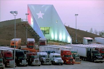
spacer View of the new Gray County Safety Rest Area
View of the new Gray County Safety Rest Area
spacer 

Location

  • IH 40 - Westbound, just west of Alanreed
  • Latitude = 35.1985 Longitude = -100.7982
  • Milepost: 131

Features

  • 2 sets of Men's and Women's Restrooms
  • Picnic Tables
  • Air-conditioned lobby and restrooms
  • Playground
  • Diaper Changing stations
  • Separate Truck and Passenger Parking
  • Drinking Water
  • Storm Shelter
  • Family/Assisted Restroom
  • Vending Machines
  • Handicap Access
  • Walking Trail
  • Interpretive Displays

  •  

    Miscellaneous

    • Newly constructed facility opened in Spring 2003
    • Facility's "Cap Rock" design gets its inspiration from the natural rock outcropping common in the area. Interpretive exhibits inside the lobby provide local information, road and weather conditions
    • Equipped with a wind turbin to supply renewable energy to the facility
    • Gray County, formed in 1876, was named for Peter W. Gray, a lawyer and politician of the Republic of Texas and Civil War eras