Safety Rest Areas: Gray County Westbound
(New facility opened Spring 2003)
Donley County Eastbound is the partner for Gray County Westbound
|
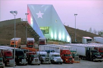 View of the new Gray County Safety Rest Area |


Location
|
Features
Miscellaneous
- Newly constructed facility opened in Spring 2003
- Facility's "Cap Rock" design gets its inspiration from the natural rock outcropping common in the area. Interpretive exhibits inside the lobby provide local information, road and weather conditions
- Equipped with a wind turbin to supply renewable energy to the facility
- Gray County, formed in 1876, was named for Peter W. Gray, a lawyer and politician of the Republic of Texas and Civil War eras